

Watching Our Waters
A Report on Water Resource Monitoring
in the Saco Headwaters Watershed
Prepared by the Saco Headwaters Alliance and FB Environmental Associates
The Saco River rises in eastern New Hampshire and in western Maine. The upper headwaters are defined as the area above the confluence with the Ossipee River; an area slightly larger than Rhode Island. 43% of the watershed is protected conservation land. It includes mountains, broad glacial valleys, vital stratified drift aquifers, and scenic lakes and rivers. Unspoiled natural resources support the recreational tourism economy and provide a high quality of life for residents.
Abundant high-quality streams, rivers, lakes, ponds, and aquifers face dispersed threats in the form of non-point source pollution that can be carried by stormwater to streams or ponds or infiltrate into groundwater. These include nutrients from underground wastewater disposal, soil or sediment particles eroded and carried by storms, and road salt from winter deicing.
Water quality monitoring is a key component of our vision for a more resilient watershed. This report reviews the existing monitoring programs and data sources, analyzes gaps, and makes recommendations for specific actions. It also assesses the state of water resource monitoring with respect to known threats, as well as the ability to respond to newly developing threats; all essential to building and maintaining resilience.
Planning for the future
Investments in monitoring now will inform effective actions that will in turn prevent harm to our water resources that would be much more costly to restore, or worse, irreversible.
Each section of the report contributes to the pursuit of one goal: to strengthen water resource monitoring in the Saco Headwaters watershed and close key data gaps and base water protection efforts on the best science possible. A core assumption is that investments in monitoring will contribute to effective actions to prevent harm to water resources that would be costly to mitigate or restore or, worse, would be irreversible.
Programs & Data inventories monitoring programs, organizations, and data sources relevant to water protection in the watershed. A diverse network of state and federal agencies and nonprofit organizations collects water data for many purposes and under many separate programs. Also, a close look at the geographic information system data that maps locations and boundaries of natural resources and human infrastructure.
Gap Analysis critically appraises the available data and existing monitoring programs for the ability to detect and understand water resource threats. Threats and their causes are given detailed discussion, and key gaps are identified.
Strategic Action Plan proposes specific actions to address gaps in data and scientific understanding. Details are provided on each action, including the responsible entity, the timeframe, and the estimated cost.

Robust Water Quality Monitoring.
This report combines a number of components – each of which would be an important undertaking on its own – in pursuit of one goal: to strengthen water resource monitoring in the Saco Headwaters watershed so that key data gaps can be closed and water protection efforts can be based on the best science possible. A core assumption underlying all of this work is that investments in monitoring now will inform effective actions that will in turn prevent harm to our water resources that would be much more costly to restore, or worse, irreversible.

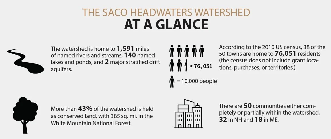
The Saco Headwaters Watershed—lands and waterbodies that drain into the Saco River and its major tributary the Ossipee River—covers 1,294 square miles in eastern New Hampshire (Carroll, Coos, and Grafton counties) and western Maine (Cumberland, Oxford, and York counties). It encompasses 19 communities (13 in New Hampshire, 6 in Maine), an additional 31 communities partially within the watershed (19 in New Hampshire, 12 in Maine) and is home to 76,051 residents. The watershed includes over 1,591 miles of rivers and streams, 140 named lakes and ponds, 1,648 unnamed lakes and ponds, an unknown number of intermittent headwater streams, springs, and seeps, and two important stratified drift aquifers —the Ossipee and Upper Saco aquifers—that provide drinking water for many municipalities, homes, and businesses in the region and receive their recharge waters from precipitation, infiltration, and stream seepage.
The action plan addresses known threats and steps to respond effectively, and it also strengthens a monitoring program that can detect new threats as they arise. Resilience demands attention to known unknowns and to unknown unknowns. The purpose of this work is to build a toolbox of watershed-wide diagnostic tools to guide threat prevention and rapid remediation across the watershed ecosystem that is scientific and data-based, and that employs continuously improving 21st century technology.